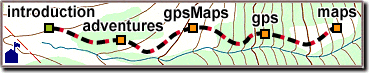
Acquiring Satellites
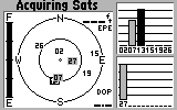 When first turned on,
a GPS receiver starts listening for satellite signals.
On the "satellite display" here,
the numbered satellites appear somewhere in the sky.
The middle of the diagram is directly overhead,
and the smaller circle is halfway up (45 degrees).
The horizon is the large circle
with four compass points: N, S, E, W.
Signal strength is also shown for each satellite.
When first turned on,
a GPS receiver starts listening for satellite signals.
On the "satellite display" here,
the numbered satellites appear somewhere in the sky.
The middle of the diagram is directly overhead,
and the smaller circle is halfway up (45 degrees).
The horizon is the large circle
with four compass points: N, S, E, W.
Signal strength is also shown for each satellite.
Your receiver needs a 30-second message
from each satellite to use it for navigation.
During this time, the signal strength bar is hollow,
and the satellite is not usable.
Once a complete message is received,
the signal bar turns solid and the satellite is "locked".
Your receiver may remember a locked satellite
for several hours, even while turned off,
making acquisition quicker the next time.
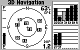
More satellites means less error.
For an accurate GPS location,
wait for a lock on most or all of the available satellites.
Always try to maximize your coverage,
even beyond the four satellites needed for navigation.
Even with a good view of the sky,
acquisition can sometimes be difficult and slow.
GPS signals shift frequency a lot -
predictably, in a programmed sequence,
and unpredictably, from speed and temperature variations.
 Searching for all 24 satellites
could take 10 minutes or more.
Instead, your receiver stores an "almanac"
of satellite locations and listens for overhead ones first.
If the receiver has moved a long way,
those satellites aren't there.
You can then either suggest a location,
or "auto-locate", which may take several minutes.
Searching for all 24 satellites
could take 10 minutes or more.
Instead, your receiver stores an "almanac"
of satellite locations and listens for overhead ones first.
If the receiver has moved a long way,
those satellites aren't there.
You can then either suggest a location,
or "auto-locate", which may take several minutes.
|
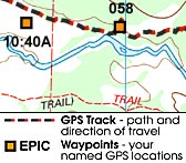 Most recreational GPS receivers can store
the locations that interest you as "waypoints",
and many can record your "track" -
the path you take to get there.
Most recreational GPS receivers can store
the locations that interest you as "waypoints",
and many can record your "track" -
the path you take to get there.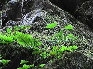
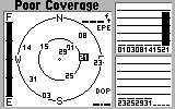 Trees are often found outside, as are
mountains, canyons, tunnels, and buildings.
All of these can block satellite signals,
making it difficult to keep the four needed for navigation.
You may see "poor coverage" when your receiver
can no longer navigate.
Trees are often found outside, as are
mountains, canyons, tunnels, and buildings.
All of these can block satellite signals,
making it difficult to keep the four needed for navigation.
You may see "poor coverage" when your receiver
can no longer navigate.
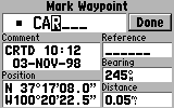 Before marking your favorite locations as GPS "waypoints",
make sure the receiver has a good "3D" navigation lock.
For permanent marks, pick a name you'll remember.
Temporary marks can usually be numbered automatically.
To restart waypoint numbering, erase any numbered waypoints
and save a new one called "001".
Before marking your favorite locations as GPS "waypoints",
make sure the receiver has a good "3D" navigation lock.
For permanent marks, pick a name you'll remember.
Temporary marks can usually be numbered automatically.
To restart waypoint numbering, erase any numbered waypoints
and save a new one called "001".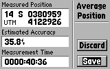 Some receivers allow you to accumulate an average
position over several minutes or hours.
Place the receiver with a good view of the sky,
start the average, then take a break.
When you're ready to move on,
save the result as a waypoint.
Some receivers allow you to accumulate an average
position over several minutes or hours.
Place the receiver with a good view of the sky,
start the average, then take a break.
When you're ready to move on,
save the result as a waypoint.