prev
gpsMaps
next


Climbing Ivy


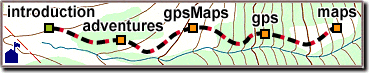
Custom GPS Topographic Maps

This section is about Wild Rose gpsMaps and how they're made, including options, prices, and ordering information.

Our focus is helping you map your world. You record locations and trails with a GPS receiver, and we'll plot them on a topographic map.

We also offer USGS topo maps with the UTM grid drawn in for accurate use with a GPS receiver. Our free Map-Finder service can help you pick the right maps.

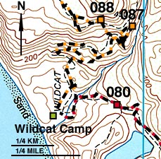
High-resolution digital maps, illustrated maps, and other web or print graphics are also available. For do-it-yourself types, a complete gpsMap software package should be available by mid-1999.

This gpsMap is part of a backpacking trip to Point Reyes National Seashore, CA.

NOTE: Mapping takes plenty of time and effort. Our contract programming work is also time-consuming, and that work is currently crowding out the possibility of taking on new map work. Please feel welcome to write or call. We enjoy being helpful, and sharing a love for maps, gps, and the great outdoors.

Getting Started

A gpsMap starts with a concept: hiking the Sierras from border to border, tracking rare birds, your pursuit of the perfect fishing spot or mountain bike workout. It's inspiring to go on an adventure, then return and map where you went and what you found.

A gpsMap is a great way to share an outdoor experience, and we can include text, graphics, photos, or graphs, creating a useful reference for teaching, business, or science.


Wet Moss


GPS Data

Collecting good GPS data is both art and science, so be sure to check out the "GPS Hints" and "Map Hints" chapters. We'll answer all your questions, help you collect accurate data, and decide on a gpsMap style that works best for you.

GPS receivers can usually talk directly to your computer, transferring stored data so you don't have to write it all down. You'll need an interface cable and software. Both are usually available from the GPS receiver manufacturer, and there are other sources - even free software.

If you already know maps and GPS, this chapter describes our products, options, prices, and has complete ordering information.

gpsMap Accuracy

Our process is calibrated from start to finish, with accuracy of 15 meters or better at 1:24,000 scale, but a gpsMap can only be as accurate as the coordinate data, and the Base Map we use. Both GPS Hints and Map Hints chapters contain information about accuracy and the types of errors you may encounter.


Base Map

A gpsMap shows your GPS locations and trails over a Base Map, made from one or more printed maps. We have hundreds of maps on-hand, and thousands more available within a day. If your data crosses a map boundary, there may be a line, or a slight change in style.

It's cheaper to reuse your base map for new data, so you may want to specify the area of coverage, either by coordinates, or just describe the boundaries. You can also get just a digital or printed base map.

Let us know ahead of time if your data needs editing, or if your map needs to cover a specific area. We'll try to fit the map to a single page, or give you some options along with a test plot.


packages
gpsMap Packages

Wild Rose gpsMaps come in 4 standard "packages": Quick, Full, and Custom Plots, and illustrated Production Maps. You can get a Test Plot of your data free with any of the above, or separately for $9 per page.

If you need a service that isn't here, just ask and we'll make one up. "Custom" is our middle name.

Rates are per letter-size page, or equivalent compressed computer file by e-mail or floppy disk. Larger prints and computer files are available for a an additional charge. A complete price list follows these descriptions.

Quick Plot

For $19 per page, we can plot your coordinate data on a "Quick Plot" gpsMap. You get to see what your points and trails look like over a full-color topographic map - just like the examples here.

Individuals and small organizations can use a Quick Plot to plan or document an adventure at an affordable price. A Replot over the same base map is only $9.


Vine Yard

Full Plot

A "Full Plot" is a gpsMap customized with your own text, pictures, and graphics. For $29 per page, we'll create a flyer for your cycling or equestrian event, or plot a backpacking or cross-country trip, complete with pictures and descriptions.

We'll need instructions and/or a drawing, with the exact text and placement of graphics. Pictures can come from print, video, or computer file, but we can't use copyrighted material without permission.

You can upgrade a Quick Plot to Full Plot for $10, and we'll Replot either the data or the text/graphics for $9 (both for $18). More than 12 text/graphic elements is usually a Custom Plot.

Custom Plot

The "Custom Plot" is a complete gpsMap project for $39 per page, with lots of text and pictures to explain and entertain. We can average multiple waypoints or tracks to improve accuracy.

Photographers or videographers can plot where pictures are taken on a PicMap. Recreational or scientific gpsMaps can include map insets, data graphs, or color-coding for time, speed, trail grade or altitude. Combinations of the above are fine, but all at once would be extra.


prev
gpsMaps
next


Production Map

A "Production Map" is a custom illustrated map or brochure for recreational, business, or scientific use. Because published maps need to convey information clearly and quickly, you'll usually want to avoid much of the detail of USGS maps. A brochure for a campground or vineyard are good examples.

We start with an accurate base map, but only as a guide for a drawn-to-order, illustrated map. We use the latest desktop-publishing software, combined with many years of graphics experience.

Call us for an estimate or quote. We'll enjoy learning about your business and discussing the type of publication you need.


NEXT: gpsMap Rates, Output, Ordering


the Wild Rose Website
site map - the Wild Rose website
[home] [introduction] [adventures] [gpsMaps] [gps] [maps]