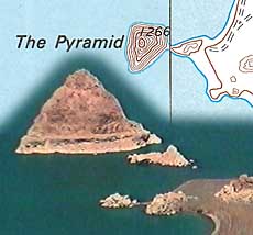
 The picture was taken from a point Southeast of the map inset.
The lake level is higher on the picture,
where the mapped shoreline is partly flooded.
The picture was taken from a point Southeast of the map inset.
The lake level is higher on the picture,
where the mapped shoreline is partly flooded.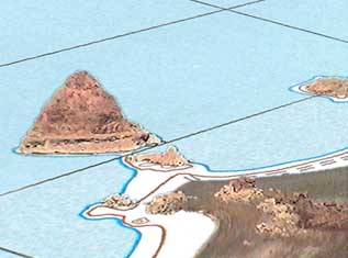 Here, picture over map shows the difference in water level,
and the tricks you can do with Adobe Photoshop.
Here, picture over map shows the difference in water level,
and the tricks you can do with Adobe Photoshop.
|
|
|